 |
Integrated Sustainability Analysis |
 |
| Home Contact Search Media |
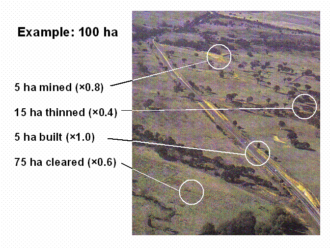
Ecological Footprints that reflect the impact on actual landIn conventional Ecological Footprints, the areas of forest, pasture and crop land do not represent real land, but hypothetical areas that would be needed to support the consumption of the population, if local farming and forestry was conducted at 'world average productivity'. Proceeding as such makes it easy to compare ecological footprints of different countries or populations. However, the loss in detail through the conversion to world-average productivity makes it impossible to use an ecological footprint for formulating regional policies, because the latter always involve region-specific economic, political, technological, environmental and climatic aspects. Furthermore, bioproductivity appropriation does not yield insights about regional impacts on land and ecosystem processes, and therefore does not indicate the sustainability of regional land use. In the original ecological footprint, land categories are weighted with equivalence and local yield factors in order to express 'appropriated bioproductivity' in world-average terms. However, the intensity of human-induced changes to land is independent of productivity. Land converted to roads and buildings, used for mining or for intensive cropping whether productive or not is drastically altered from its natural state, whereas land used for non-intensive grazing or native forestry may be only slightly altered. This land condition, or the deviation from a pristine state is not captured in the productivity-based approach of the original concept. For example, in the original method, the estimation of the ecological footprint for beef consumption by a population is simply the land area that would be needed for the corresponding amount of cattle if the grazing land had world average productivity. However, it is clear that in Australia, cattle farms in different parts of the country are subject to vastly different climates and soil types, and that individual farmers have very different management strategies for their cattle. In addition, some farmers have cleared their lands of natural vegetation much more extensively than others. More extensively cleared land has initially been impacted upon more greatly than less cleared land, and in addition, extensive land clearing is known to cause problems of soil salinity and erosion. Under the original method, it is not possible to distinguish these underlying parameters. For this reason, we argue that a better approach is to base the ecological footprint on land condition, using actual areas of land used by the respective population. The measurement of land condition forms a field of investigation in itself, and a number of approaches have been made in studies incorporating land use into life-cycle assessment. Amongst others, ecosystem biodiversity and bioproductivity measures as well as species diversity of a particular group of plants have been proposed as suitable indicators. For Australia, the degree of landcover disturbance may be a useful proxy for land condition at a very broad scale, as it indicates processes such as biotic erosion that lead to land degradation. A comprehensive survey of landcover disturbance over the Australian continent has been conducted by the CSIRO, using satellite imagery to compare the current coverage of vegetation with the 'natural' state, taken to be that of 1788. Based on these authors disturbance categories, we have derived a list of weightings for different types of land use ranging from 0 (undisturbed or slightly disturbed) to 1 (completely disturbed). Basic weighting factors for land use, reflecting land condition in Australia. To obtain a disturbance-based ecological footprint, each area of land is multiplied by its land condition factor. An example of this procedure is provided in the figure below: the 100-hectare area shown in the photo includes a road (5 ha), a quarry (5 ha), cleared land (75 ha), and some less intensively cleared (thinned) land (15 ha). In the original ecological footprint calculation, these areas would all be treated as equivalent, and simply be added. In a disturbance-based approach, however, each area would be weighted with a land condition factor (see figure below), yielding 5 ha × 1.0 = 5 ha disturbance on built land, 5 ha × 0.8 = 4 ha on mined land, 75 ha × 0.6 = 45 ha on cleared land and 15 ha × 0.4 = 6 ha on thinned land. These figures demonstrate the effect of weighting: each part of the land receives a value that reflects both its area and its condition. Notwithstanding significant methodological improvement, current ecological footprints cannot really indicate sustainability of regional land use, because neither productivity, nor land use, nor land disturbance are indicators that are directly related to sustainability. Ecosystems, climates, farming and forestry methods differ regionally: in some areas, the combination of climate, local ecosystems, and forestry or farming practices may ensure that even intensive land use activities may continue indefinitely. In other areas, local ecosystems could be more fragile, with the result that the land could become unsuitable for the current use, even if non-intensive farming or forestry methods were applied. In order for the ecological footprint to be a more useful and direct indicator of sustainability, detailed data on the unsustainability of various activities, and the resilience of ecosystems need to be collected, and a method developed by which to incorporate these data in the ecological footprint. Linking land use and land disturbance with the sustainability of biological systems is perhaps most difficult, especially at a large scale (national or regional), due to these systems' inherent complexity and our lack of knowledge. Ecologists have long recognised that most ecological sustainability issues, like the loss of biodiversity, are the result of slow changes reflecting decades to centuries of accumulation of various human-induced pressures on marine and terrestrial ecosystems. Moreover, these changes in ecosystems are often not linearly related to environmental pressures, but may, for example, have thresholds after which sudden change occurs. However, while lacking explicit information on sustainability, focusing on land disturbance rather than productivity or land use is a first attempt to account for processes that contribute to unsustainability. For further information please contact
|